GuidesUpdated 8 min readFloorGen team
How to Draw a Site Plan for a Building Permit
What a site plan for a building permit must show: lot lines, setbacks, easements, north arrow, driveway and utilities, with a worked 80 × 110 ft lot.
A site plan for a building permit is a scaled drawing of your whole lot, seen from above, that shows the property lines, every existing and proposed building, the distances from each building to the lot lines, and the driveway, easements and utilities. You draw it from your survey or recorded plat, at a stated scale, with a north arrow. The building department uses it to check zoning (setbacks, coverage) and the planning and utility reviewers use it to see what you are changing on the ground.
Why the permit office asks for a site plan
The floor plans show what is inside the building. The site plan shows where the building sits. Under Section R106.2 of the 2021 International Residential Code (IRC), the construction documents for a permit must come with a site plan showing, to scale, the size and location of new construction and existing structures on the site and their distances from lot lines, along with street grades and proposed finished grades. Many departments use the term plot plan for the same sheet.
Most of what a site plan is checked against is not building code at all. It is zoning: how far the house must stay from each lot line, how much of the lot it may cover, how large it may be relative to the lot, and where the driveway may meet the street. That is why a plan reviewer will often bounce a site plan with a missing setback dimension even when the floor plans are perfect.
What a site plan for a building permit must show
Checklists vary by city and county, so get your department's residential submittal list first. The items below appear on almost every one:
| Item | What to draw or write |
|---|---|
| Property lines | Every lot line with its length (and bearing, if your survey gives one), copied from the survey or plat |
| Street and access | Street name, curb or edge of pavement, sidewalk, and the driveway with its width |
| Buildings | Existing and proposed buildings, outlined to the outside of the walls, labeled "existing" or "new" |
| Setbacks | The distance from each wall to the nearest lot line, front, both sides and rear |
| Easements | Utility, drainage and access easements, with their widths, shaded or hatched |
| Utilities | Water, sewer or septic and drain field, gas, electric service and meter locations |
| North arrow and scale | A north arrow, the written scale and a graphic scale bar |
| Lot data | Lot area, footprint area, lot coverage and (if your zone has one) floor area ratio |
| Grades and drainage | Spot elevations or contours where required, and the direction water flows off the lot |
| Other site work | Decks, patios, pools, fences, retaining walls, accessory buildings, trees to be removed |
Two of these trip up homeowners most. Easements are on your title documents and survey, not on the ground; a shed or an addition over a utility easement can be refused even when the setbacks work. Utilities matter for additions and ADUs, because new plumbing has to reach the sewer main or septic tank, and a septic drain field usually has its own required clearances from buildings and wells.
Start from the survey
Do not measure your lot lines with a tape and a guess at where the fence is. Fences, hedges and curbs are often a few feet off the true line. Use one of these, in order of preference:
- A boundary or mortgage survey from when you bought the house. Many departments accept it if it shows current conditions.
- The recorded plat for your subdivision, from the county recorder. It gives lot dimensions and easements but not your house.
- A new survey from a licensed land surveyor. Some departments require one for new houses, additions near a setback line, or any work within a few feet of a lot line.
County GIS parcel maps are useful for a first look but are not survey-accurate, and most departments will not accept them as the basis of a site plan.
A worked site plan: the ranch on an 80 × 110 ft lot
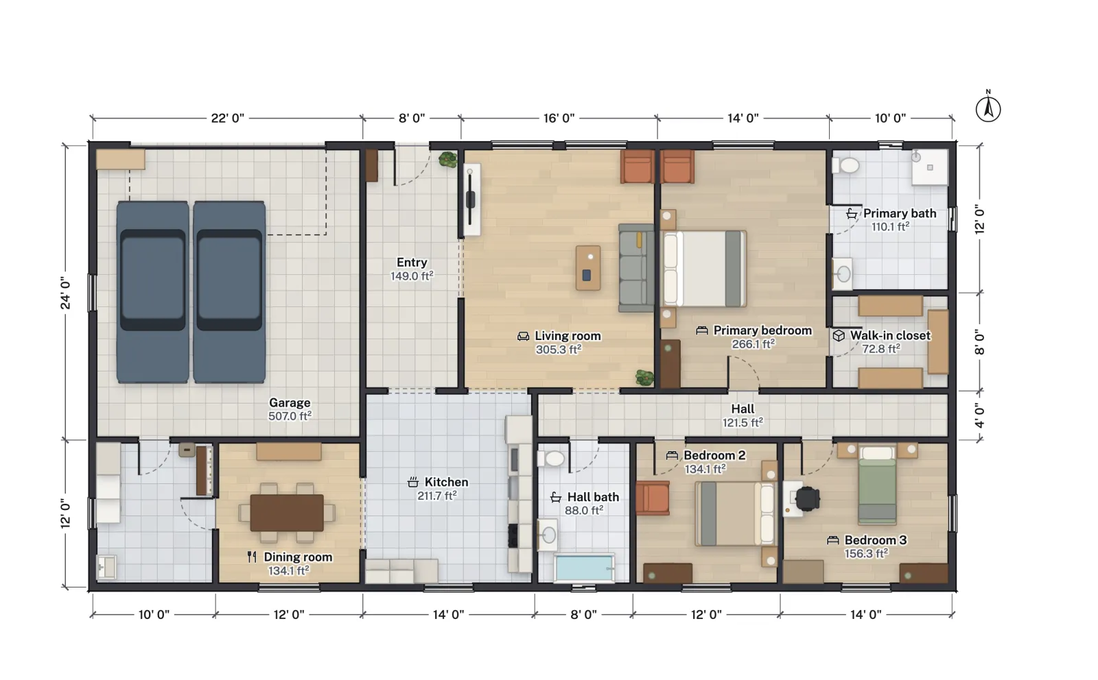
FloorGen's 3-bed ranch with 2-car garage template comes on its lot, which makes it a handy example. The lot is 80 × 110 ft, or 8,800 ft² (FloorGen prints 8,799.8 ft² because it stores lengths in metric). The house is 70 × 36 ft on the wall centerlines, about 70 ft 6½ in × 36 ft 6½ in to the outside of the walls, and covers 2,577.6 ft² measured outside. The front door and the 16 ft garage door face the top edge of the lot, the street side in this drawing.
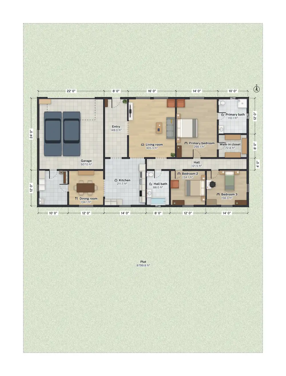
The template places the house by its wall centerlines: 25 ft from the front lot line and 5 ft from each side. A site plan should dimension to the outside face of the wall, because that is what zoning measures (and the IRC fire separation rules below measure the same way). The exterior walls are 6½ in thick, so the faces sit 3¼ in closer to each line:
| Lot line | To the wall centerline | To the outside face |
|---|---|---|
| Front (street) | 25 ft | 24 ft 8¾ in |
| West side | 5 ft | 4 ft 8¾ in |
| East side | 5 ft | 4 ft 8¾ in |
| Rear | 49 ft | 48 ft 8¾ in |
That small difference matters here. Under 2021 IRC Table R302.1(1), an exterior wall with a fire separation distance under 5 ft must be 1-hour fire-resistance rated, openings are limited to 25 percent of the wall between 3 and 5 ft, and none are allowed under 3 ft. At 4 ft 8¾ in, both side walls of this template fall just inside that band. On a real lot you would slide the house or shorten it a few inches so each face clears 5 ft, or rate the walls and check the windows. Your zoning side setback may be larger than 5 ft anyway; see zoning setbacks explained.
The lot data block for this example is simple arithmetic: 2,577.6 ÷ 8,800 = 29.3 percent lot coverage measured to the outside of the walls, garage included. A one-storey house without a basement has the same floor area ratio, about 0.29, if your code counts the garage. The lot coverage and FAR guide works through what counts and what does not.
How to draw it, step by step
- Pick a drawing scale that fits the lot on one sheet. 1 in = 10 ft, 1 in = 20 ft and 1/16 in = 1 ft are common for house lots; write it on the sheet and add a scale bar.
- Draw the lot lines from the survey, with each length written along the line. Mark the street side.
- Place the building footprints to the outside of the walls, existing in one line weight, new work in a heavier one or hatched.
- Dimension every setback: a line from each wall, perpendicular to the nearest lot line, with its length. Include porches, decks and covered stoops; many zones measure to them too.
- Add the driveway with its width and the curb cut, walkways, patios and any accessory buildings.
- Shade the easements and label them with type and width.
- Show the utilities: where water, sewer or septic, gas and electric enter the lot and the house.
- Add a north arrow, the address and parcel number, the lot data block, and your name and date.
Drawing the lot in FloorGen
FloorGen is a floor plan editor, but it handles the parts of a site plan that come from your lot dimensions:
- Blank plot: start a new project from a plot width and depth, in feet or meters, and FloorGen draws the lot as a grass surface with a north arrow, so you can fit the house inside its edges. It defaults to 70 × 120 ft.
- Plot size on any project: the building summary takes a plot width and depth and reports plot coverage and FAR from the floor areas.
- Surfaces for a driveway or patio: draw a rectangle or click corners, and drag a corner to reshape it. The lot surface can be reshaped the same way for an irregular lot, though the coverage figure uses the plot width and depth.
- Tape measure and dimensions: pin a measurement from a wall to a lot line, or add a dimension that follows the walls when they move.
- Text notes and the north arrow (in Project details, from the account menu at the top right), which you can turn to match your survey.
- Print set: a PDF with a sheet per floor at a real scale and a title block.
What it does not do: it does not know your real lot lines, easements, grades or utilities, and it does not check setbacks or zoning. Copy those from your survey and check them against your zoning code yourself.
Common reasons a site plan gets sent back
- A setback is missing, or is measured to the foundation when the zone measures to the eave or porch.
- No scale, or a scale that does not match the printed sheet. Keep the scale bar so a reduced print still measures.
- Lot lines drawn from the fence instead of the survey.
- Existing sheds, decks and pools left off. They count toward coverage in many zones.
- Easements not shown, or new work drawn over one.
- No north arrow, address or parcel number.
More from the blog
Guides7 min read
What Is a Setback? Zoning Setbacks ExplainedGuides6 min read
Floor Area Ratio (FAR) and Lot Coverage: How to CalculateGuides6 min read
Exterior Elevation Drawing: What It Shows and How to Make One